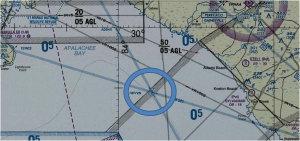
I know where HEVVN is. I have coordinates for it.
“HEVVN” is the politically correct, government approved spelling for a place pronounced, as you might expect, “Heaven”. I’ve been there, and I could go again today if I wanted. But since I’m still a living, breathing person I can’t stay there.
It should come as no surprise to you that HEVVN is not a town or city; it’s nowhere on land. It’s not an island: it’s not on the water. It can best be described as an ephemeral place somewhere in the “air”; in space if you will.
Theoretically, an infinite number of people could be at HEVVN all at the same time, without actually being at the exact same place at the same time. There is, in other words, considerable spatial ambiguity, uncertainty, about where one might be in HEVVN. In an earthly sense, two people at HEVVN might be miles apart, not even able to see each other, not even aware of each other’s presence.
I would guess that on a typical day, thousands arrive at HEVVN: on a slow day, maybe merely hundreds.
If the government admits to a HEVVN, does it admit to a HELL? Well, not exactly. But it does admit to a SATAN.
But don’t worry – if you’re at HEVVN, you won’t be anywhere near SATAN. HEVVN and SATAN are a thousand miles apart.
I’m still being serious…really.

Are you confused? Well, here’s an explanation. HEVVN is a Federal Aviation Administration defined airway intersection used, along with an assigned altitude, to define an aircraft’s position. HEVVN lies roughly ten miles off the coast of the Florida Panhandle, and connects the major flyways of the Florida Panhandle and the north-south air corridors of the Florida penisula. Theoretically many aircraft can simultaneously be at HEVVN, as long as they are separated by at least 500 feet in altitude.
Oddly enough, SATAN is included in a much more innocent sounding group of GPS fixes, those defining a GPS approach to runway 16 at Pease Airport. When cleared for the GPS 16 approach coming from the west, the aircraft is expected to follow sequentially a route to the airport using up to five GPS fixes. Those five fixes, including the two “missed approach” fixes used in case a pilot can’t find the runway due to low clouds, are named thusly:
ITAWT ITAWA PUDYE TTATT … IDEED.
Apparently someone at the FAA has a sense of humor.
If you’re not laughing, you might want to say those five words in quick succession. If you’re still puzzled, try repeating it with your best Tweety Bird impression.
After the FAA named a point in space SATAN, someone must have decided some comic relief, à la Warner Brothers, was needed. And a famous quotation from the canary named Tweety Bird somehow seemed appropriate.
After all, Tweety Bird can fly. Right?


